Gondi Irrigation Information System


Gondi Progress path
About Gondi Project x
Gondi Irrigation Information System
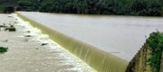
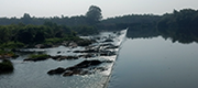
The Gondi Anicut, located at about 14.50 km downstream of the Bhadra Dam, is built across the Bhadra River near Gondi Village, 11.56 km from Bhadravati Town, Shivamogga district. The Culturable Command Area (CCA) of the Gondi System is about 4,600 ha.
As a part of Karnataka Integrated and Sustainable Water Resources Management Investment Program (KISWRMP), Gondi Project modernization has been taken up. Key components of this modernization are
- Improvement of canals including canal lining to suit future water delivery requirements.
- Repair/ replacement of canal structures to support future operational objectives.
- Supply and installation of telemetry-based flow measurement at about 20 locations.
-
Command area development works in 4600 ha.
Capacity development of System Operations staff and Water Users Cooperative Societies (WUCS) to enable them to effectively operate and maintain the system, including the flow system, to provide improved and efficient water distribution service. - Implementation of Web based Application with GIS Database for System Appraisal, Asset Management, Monitoring and Water Management in Gondi Irrigation System.
Macro & Micro level information
This system consists of comprehensive spatial and non-spatial information encompassing all the aspects of environment i.e. land, water and society related irrigation command area management. This system is an analytical, monitoring and decision support system adopting an integrated approach that involves technologies like Remote Sensing, GPS and GIS along with field studies. This system is able to generate various types of MIS reports along with spatial decision support. Key functionalities of this system are;
- Repository of comprehensive spatial and non-spatial information system encompassing all the aspects of environment of Gondi Irrigation Project.
- Process automation in execution of Co-operation, Agriculture and Engineering activities.
- Spatial decision support facilitating.
- Map navigation, feature identification and measurements.
- Finding and locating facilities within selected Revenue / Political / Operational jurisdiction.
- Layers ON and OFF to create customized digital map view.
- View and retrieve information of interested assets / features.
- Creation of informative map with title, scale, legend etc. and to save.
- Visualize year and season wise crop area, crop water requirement and water release and demand scenario.
Macro & Micro level information
Advantages of GIIS
- 24/7 accessibility of reliable and comprehensive information content in GIIS improved ability to retrieve required information more efficiently and effectively.
- Facilitate planning and designing of preventive and reclamation measures to be taken up in command area.
- Data organized in chronological model facilitate decision makers to plan and prioritize various developmental activities.
- Assists in redressing stakeholders of this system especially farmers grievances and farming advisories.
Salient Features x
| 1 | Name Of the Project | Bhadra Anicut | |
| 2 | Location | NearBy Village / Town | Gondi |
| Taluk | Bhadravathi | ||
| District | Shivamogga | ||
| Latitude | 10 o 45' 00" N | ||
| Longitude | 75 o 45' 00" N | ||
| 3 | Catchment area in Sq.Km | 837 | |
| 4 | Yield(in mcum) | 3096 | |
| 5 | Storage in TMC | Gross | - |
| Live(above MDDL) | - | ||
| Dead(below cill) | - | ||
| 6 | Utilization in MCM | a) Withdrawals by Canals | 87.73 |
| b) Reservoir losses | - | ||
| c) Water Supply | - | ||
| c) Total | 87.73(3.10 tmc) | ||
| 7 | Dam | a) Type | masonry |
| b) Length(mtr.) | 280.4 | ||
| c) Height(mtr.) | 4.95 | ||
| d) MWL(mtr.) | 606.63 | ||
| e) FRL(mtr.) | 606.12 | ||
| f) MDDL(mtr.) | - | ||
| g) Cill(mtr.) | - | ||
| 8 | Spillway | a) Location | central |
| b) Length(mtr.) | 849.9 | ||
| c) Flood left(mtr.) | 3.5 | ||
| d) Discharge Capacity (Cumecs) | 3396 | ||
| e) Crest Gates | - | ||
| i) Nos. | - | ||
| ii) Size (in mtr.) | - | ||
| 9 | Submersion | a) Area in ha. | NIL |
| b) No of Villages affected | - | ||
| c) Population effected | - | ||
| 10 | Irrigation (in ha.) | 4,466 | |
| 11 | Canals | a) Left Bank Canal | |
| i) Length in KM. | 14.5 | ||
| ii) Capacity in cumecs | 0.56 | ||
| iii) Irrigation in Ha. | 216 | ||
| a) Right Bank Canal | |||
| i) Length in KM. | 74 | ||
| ii) Capacity in cumecs | 7.5 | ||
| iii) Irrigation in Ha. | 4466 | ||
Crop Area x
Generating Result Please Wait...
| Sl No. | Crop Name | Area in Ha | Percentage |
|---|
No Record Found.
| Sl No. | Crop Name | Area in Acre | Percentage |
|---|
No Record Found.
| Sl No. | Crop Name | Mono Crop Area in Ha | Mixed Crop Area in Ha | Gross Area in Ha | Percentage |
|---|
No Record Found.
| Sl No. | Crop Name | Mono Crop Area in Acre | Mixed Crop Area in Acre | Gross Area in Acre | Percentage |
|---|
No Record Found.
Crop Water Requirement x
| WUCS | July | Auguest |
|---|---|---|
| Baballi | 1216 | 1000 |
Crop Water Requirement x
Generating Result Please Wait...
Project Methodology And Data Source x
Project Methodology and Data Source
To facilitate realistic analysis of the conditions prevailing in the Gondi command, up-to-date spatial information of the command area has been created. Looking into the existing procedure of data / information management, a strong spatial information system for Gondi command area has been developed as a core of the model. The development of spatial data base and application for Gondi command involved following stages;
- Gondi Command area maps / drawings existing with client either in hard or digital format are being reviewed.
- Digitally converted and normalized to uniform scale.
Base Map
Readily available high resolution satellite image is used to create base map of the Gondi Project area. Transport network, Settlement locations, Water bodies such as Tank, River, Stream, Pond etc. have been created and further validated in the field.
Revenue Administration
District, Taluk and Village Revenue maps have been used to create revenue and administration boundaries from District to Cadastral
Cadastral Information
Revenue village survey maps on 1:7920 scale have been digitized and geo-referenced to create cadastral mosaic. Each survey number is linked with Farmer names. Under each survey number plots have been delineated by referring high resolution satellite image.
Canal Network Information
Readily available high resolution satellite image is referred to create canal network from main canal & distributaries. GPS devices have been used to trace Field Irrigation Channels in consultation with Department Engineers and WUCS office bearers. Also, Mobile App is used to validate the location and geometry of Main canal and distributaries to collect attributes.
Mobile Application
Android based application to create spatial database for Gondi Irrigation System has been designed and developed. Developed application is loaded to GPS enabled Mobile to map boundaries, assets and features related to irrigation management in the field such as Electric line, Canal network with assets, Anicut, Transport network with CD structures, Minor streams, Command, WUCS, PO, Plot areas, Crop inventory, Development activities and Third party inspection.
Field inventory
Required number of teams have been deployed to validate and collect various information in the field using Mobile App. Office bearers of WUCS and progressive farmers have been consulted while performing this activity. Mobile App containing survey number wise farmer names facilitated capturing of ownership details of each plot to create land holding. Crop inventory, Asset inventory, area mapping activities have been performed in the field to generate information required for Gondi Irrigation Information System.
Gondi Irrigation Information System
A comprehensive web enabled GIS application has been developed based on the data generated and collected. The system has separate modules for data entry, capture various stages of developmental activities, visualization and report generation. Overall perspective of this system is to address analysis and display capabilities with reference to command area information. Managers will be able to identify and locate various components of irrigation system and simultaneously view photograph with associated information in the web portal. Spatial and attribute query for generating spatial and non spatial report required for irrigation management is the key functionality of this system.
Required release from canal (Tentative) x
| Month | CWR | RainFall Contribution | Required Release From Canal |
|---|---|---|---|
| July | 11 | 11 | 12 |
| August | 11 | 11 | 12 |
Land Use x
Generating Result Please Wait...
| Sl No. | Category | Land Area in Ha |
|---|
No Record Found.
Water Release ForeCast x
| Month | CWR | RainFall Contribution | Required Release from Canal |
|---|---|---|---|
| 15th july 2018 | 12 | 15 | 15 |
Water level and Discharge x
| Name | Date & Time | Level in Mtr | Gross Storage(MCM) | Inflow in cuses | Outflow in cuses |
|---|---|---|---|---|---|
| Gondi Anicut | 12/12/2012 | 10.00 | 70.0 | 0.00 | 500 |
© All Rights Reserved GONDI IRRIGATION SYSTEM by SMEC & Pixel Softek Pvt Ltd
Please use Google Chrome
OR mozilla firefox For better user Experience